- Springtime snow, a “collapse” of El Niño and a surge of twisters in Tornado Alley are all possible this year as the seasons change. Get the details with AccuWeather’s 2024 U.S. spring forecast.
- The forecast was made around January 31, 2024
March 29, 2024
By Brian Lada, AccuWeather meteorologist and staff writer
State College, Pennsylvania – (highpoint Digest) – AccuWeather’s Spring Forecast is now available. Springtime snow, a “collapse” of El Niño and a surge of twisters in Tornado Alley are all possible this year as the seasons change. Get the details with AccuWeather’s 2024 U.S. spring.

“In like a lion out like a lamb,” is a phrase synonymous with March, and it will be accurate for at least part of the United States this year as meteorological spring gets underway.
“It could come in like a lion in the East,” AccuWeather Veteran Meteorologist and Long-Range Forecaster Paul Pastelok said. “We may have a pretty stormy pattern from late February to the start of March.” However, he warned that it won’t be the case across the entire country.
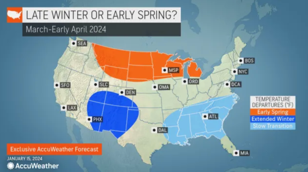
Pastelok and AccuWeather’s team of long-range forecasters also have the scoop on Punxsutawney Phil, who, on Feb. 2, will make the call on whether there will be an early spring or six more weeks of winter. Springlike weather could be late to arrive in more than a dozen states across the southern United States, while an early end to winter is possible in regions of the Northern tier.
Meteorological spring kicks off on Friday, March 1, while astronomical spring begins on the equinox, which takes place at 11:06 p.m. EDT on March 19.
When can folks safely stow away their snow shovels for the season? Will severe weather be hyperactive in Tornado Alley? How long will El Niño continue? Find out the answers to these questions and more with the region-by-region breakdown of AccuWeather’s 2024 spring forecast:
Spring snow to precede surging warmth
The snow drought finally ended in major cities along the Interstate 95 corridor following more than 700 consecutive days without an inch of snow accumulating — and there will be more chances for snow as spring gets underway.
The window of opportunity for snowstorms in the East will remain open through the first half of March, bringing the chance of plowable snow and providing a nice boost to ski resorts across the region. Afterwards, the weather pattern will flip and the risk of significant snowfall will diminish for most of the East Coast.
“We may actually see a warmup in the second half of March across the eastern U.S.,” Pastelok said. He added that there could be some additional chances for snow across the interior Northeast into April, but the odds for meaningful snow accumulation in places like New York City, Philadelphia and Washington, D.C., will be low after mid-March.
A spring storm covers tulips in fresh snow on April 30, 2019. (Photo by RJ Sangosti/MediaNews Group/The Denver Post via Getty Images)
The stormy pattern will not let up despite the surge in temperatures, and the abundance of rainfall in April could bog down parts of the eastern U.S., especially across the Southeast.
Drought conditions have been improving across the region throughout the winter months, and systems swinging through the Southeast will continue to erase the rainfall deficits in the coming months. However, the rain could end up being too much of a good thing.
Springtime rainstorms will have the potential to trigger flooding from the Gulf Coast through the mid-Atlantic, including around Charlotte and Raleigh, North Carolina; Orlando and Tallahassee, Florida; Atlanta; and Richmond, Virginia.
The prospects of frequent rainfall in the Southeast could also limit temperatures, resulting in a slower transition from winter to spring conditions.
As the calendar flips to May, residents across the Southeast should also start to prepare for the impending Atlantic hurricane season, as 2024 could feature a tropical system before the season officially gets underway on June 01, 2024.
“It may not take much to get a tropical storm in May to form, especially around the Florida Peninsula and maybe southeast Texas where water [in the Gulf of Mexico] is warmer,” Pastelok explained. However, any system that tries to develop would have to battle disruptive winds expected over the Gulf of Mexico throughout most of May, which could work to limit the system’s strength.
Tornado Alley to reignite in April, May
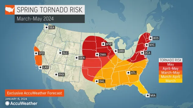
The arrival of spring signals the start of severe weather season across the nation’s heartland, and AccuWeather meteorologists say the worst of the thunderstorms and tornadoes could focus on a different area than recent years when severe weather blitzed the Tennessee Valley and Mississippi Valley.
Severe weather may fire up early across the Gulf Coast states in March and will shift and expand across the Plains through April and into May, encompassing the traditional Tornado Alley. Damaging winds and hail will be most prevalent while the number of tornadoes throughout the season could finish slightly lower than the historical average, especially in March and April.
“May is when the tornadoes start to really come about,” Pastelok said.
Parts of the mid-Atlantic and New England can also expect an uptick in severe weather in May as well.

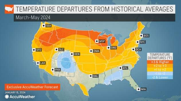
Farther north across the Midwest and northern Plains, spring warmth is likely to arrive earlier than the historical average, but dry spells and pockets of drought could limit the severe weather potential until later in the season.
A lack of snow throughout the winter has been one factor in the drought, but Pastelok said that the drought is not expected to get any worse heading into spring. There is also some good news for farmers and gardeners across the region.
“As far as the growing season goes, this is actually going to be good for planting,” Pastelok said. Dry spells in the spring will allow farmers to spend more time working in the fields earlier in the season and potentially allow them to plant more compared to a wetter spring.
El Niño may ‘collapse’ as spring begins in West
El Niño drove the weather pattern across the West Coast throughout the winter, and while the storms have not been as prolific as they were during the winter of 2022-23, rounds of rain drenched areas from Seattle through Los Angeles while yards of snow piled up in the mountains. But change is on the horizon.
“El Niño has peaked out; we are going in the other direction now,” Pastelok said. He added that “El Niño may collapse” as the water temperatures near the equator of the eastern Pacific Ocean cool off and trend closer to long-term averages. El Niño is declared when water temperatures in this region of the Pacific Ocean are at least 0.9 of a degree Fahrenheit (0.5 of a degree Celsius) above the historical average for more than three consecutive months.
Despite the shift, the stormy pattern is likely to persist into the first part of spring before the wet season concludes.
The storm track will gradually retreat northward throughout the spring, allowing long stretches of dry conditions across California. The shift cannot come soon enough for some locations, including San Diego, where flooding ensued after its fourth-wettest day on record.
Stormy weather is likely to linger longer in Washington, Oregon and Idaho.
“The Northwest actually could get a little bit wet again as we head into May,” Pastelok added.

Spring as a whole is forecast to be warmer than the historical average across the majority of the West with the exception of the Four Corners, where winter’s chill could hang on longer than other regions.
The widespread warmth will fuel snowmelt in the mountains across the Rockies, Cascades and Sierra Nevada, which will trickle down into rivers and reservoirs, but it is not expected to bring the same flooding issues experienced last spring. In California, the overabundance of snowmelt last spring led to a “ghost lake” appearing for the first time since 1997.
“We don’t have the snowpack that we saw from last season in the Rockies,” Pastelok said. “So I don’t expect extreme flooding.”
Melting snow throughout the spring and into summer will continue to fill water reservoirs across the region, including some of the most crucial reservoirs in the West.
In January, the water level in Lake Mead surpassed 1,070 feet for the first time since 2021. The water level on the lake will gradually rise into the summer as the snow that has fallen over the Rocky Mountains melts and feeds rivers. This snowmelt will help to supply water to farms and cities during the driest time of the year.
Source: AccuWeather
Images courtesy of AccuWeather


